5. Future Plans |
| Extension | Collaborations | Data | Publications | Next Phase |
5.1 Extension of pilot project
Work on the pilot phase of GSWP is continuing beyond the scope of the original plan, as outlined in IGPO (1995). Continuing work during the interim before the release of a follow-up data set from ISLSCP has two motivations. One motivation comes from the discoveries that have been made in during the process of conducting the pilot phase. All of the groups involved have found interesting problems and scientific questions which merit further examination. A second motivation comes from the questions raised at the LSP/SVAT workshop held during February 1997 in La Jolla, California, sponsored by GEWEX and IGBP.
Because no validation can be conducted on the data from the LSPs until the LSP integrations have been completed and checked for errors, the Validation Team had less time to conduct thorough investigations. So, even as this report goes to press, validation efforts are continuing.
In the realm of inter-comparison, we hope to extend the preliminary work to evaluate the spread among the simulations by the participating models as a measure of the uncertainty in current representations of modeled surface fluxes, temperatures and reservoir quantities. In particular, relative spread likely varies in space and time. This may be an indicator that certain climate regimes or certain parameterizations are deserving of more immediate attention from model developers.
In addition, more thorough investigations of the impact of the GSWP products on climate model simulations at the seasonal time scale will be conducted. Namely, we plan to investigate the impact of using soil moisture products from disparate LSPs within the same GCM. Is it possible to scale or normalize soil wetness from different LSPs so that a degree of comparability or interchangeability can be obtained? Also, would a consensus product (e.g., a simple average of the soil moisture from all LSPs) be of any value as a data set for climate modelers? Any progress in this area would be quite beneficial. In the GSWP simulations by the Production Group, a soil wetness index (SWI) was defined in an attempt to create a quantity which could be compared easily among LSPs. The SWI was defined as follows:
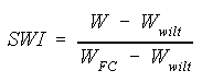
Applying this normalization to the soil moisture simulated by each participating LSP did not resolve the differences in mean soil moisture preferred by each scheme. As shown by Koster and Milly (1997) For the PILPS models, different LSPs will produce similar partitioning of surface fluxes at very different levels of soil moisture, and may produce seasonal cycles of soil moisture of similar magnitude, although the operating range of soil moisture may be quite different. Thus, it is fair to say that our a priori attempt to normalize soil moisture among LSPs was not successful. However, a method based on the fact that changes in soil moisture (as opposed soil moisture itself) is a component of the surface water balance may be more practical and justifiable. As shown earlier, Entin et al. (1998) found that removing the climatological mean soil moisture from each LSP's simulation brought the time series of soil moisture into much better agreement, and clarified the differences in the simulation of the seasonal cycle and interannual variability. Thus, it may be possible to produce a hybrid soil wetness product from the GSWP integrations, but a deeper investigation of the variability among models must be conducted.
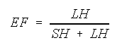
Several principle questions were raised at the LSP/SVAT workshop which can be directly addressed within the GSWP framework. One question raised was how well must soil moisture be known to simulate surface fluxes to within observational error (approximately ±10%). Surface fluxes are described as an evaporative fraction:
A second question raised at the LSP/SVAT workshop was whether sub-grid heterogeneity plays a significant role in the simulation of fluxes within realistic distributions of vegetation. This can be addressed at the resolution of climate models by aggregating up the 1×1 land surface data to a coarser scale (2×2 or larger) and reintegrating the LSPs at a coarser resolution in one case, and averaging the fluxes from the original simulations in the other case. Comparison of the cases may reveal something about the utility of simulation at finer scales, and about how methods of scaling may affect results.
Also brought up as an issue was the impact
of phase changes of soil water over the third of the land surface where
freezing and thawing occur. Initial studies with the BASE model (Desborough
and Pitman 1998) have used the GSWP framework to explore the uncertainty
in high latitude runoff resulting from differences in the parameterization
of freezing soils and impacts on runoff . Comparisons have been made between
the observed total runoff for the Mackenzie river and the results from
versions
of BASE with and without soil freezing, and with parameterizations based
on SiB and SiB2. Initial results suggest that BASE is very sensitive to
these changes, and that if BASE uses either of the SiB or SiB2 parameterizations,
the performance of the model is significantly impaired. Broadly, we find
that among the GSWP models, those using the SiB or SiB2 parameterizations
grossly over-estimate the runoff, and that BASE using these parameterizations
performs very much like other models using these SiB-based parameterizations.
What is more surprising, is that the best version of BASE, in these experiments,
is one which prevents frozen soil moisture forming.
As of mid-1997, GSWP has developed a co-affiliation with the program called Biospheric Aspects of the Hydrologic Cycle (BAHC), a core project of the International Geosphere Biosphere Programme (IGBP). BAHC is an interdisciplinary project combining and integrating expertise from many disciplines, in particular ecophysiology, pedology, hydrology, and meteorology. BAHC was a principal sponsor of the LSP/SVAT workshop, and one of its key themes is the parameterization of land-atmosphere interactions. Several of the key questions raised with respect to soil moisture and heterogeneity are addressable within the GSWP framework, and were described in the previous subsection.
GSWP is also collaborating directly with PILPS
(Henderson-Sellers et al. 1995). The two programs are highly complimentary
in their goals and foci. In one sense GSWP fills a spectral gap in the
PILPS program, by bridging the gap between the offline point and plot efforts
within phase 2, and the global coupled studies of later phases.
It is the intent of GSWP to make the 1×1 data available to the general scientific community on a monthly, if not decad, time interval. These data will be made freely available from all participating models via the Internet.
A reduced set of data may also be distributed
on CD-ROM, for wider and easier accessability. In the original GSWP plan,
it was proposed that a consensus or hybrid product, compiled from the simulations
of all participating land surface schemes, would be included. As shown
earlier, standardizing soil moisture among LSPs is not trivial. However,
the experience of ensemble modeling in atmospheric and coupled models has
shown that a simple average generally provides a superior simulation than
any individual realization, and does it quite simply. The results of Oki
et al. (1998) also suggest that in GSWP at least for runoff, the consensus
performs remarkably well. Therefore, a consensus product may indeed be
justifiable. However, an indication of the uncertainty in the fields must
accompany any consensus product -- for example, grids of standard deviation
among the participating LSPs. Nevertheless, at the end of the pilot phase,
we maintain our belief that the model-produced data sets of global surface
hydrologic and energy terms are equal or superior to previous products,
although there is certainly still much room for improvement.
.
A special issue of the Journal of the Meteorological Society of Japan on the Global Soil Wetness Project has been organized by Prof. Toshio Koike at the Hydrosphere and Atmosphere Interaction Laboratory (HAIL) in the Department of Civil and Environmental Engineering of the Nagaoka University of Technology. Support for the publication of this special issue has been provided by the Ministry of Education in Japan, and approximately 15 papers have been submitted for inclusion in the special issue. A special editorial board has been formed to overview and speed the review process. The issue will be published early in 1999.
In addition, an overview article based on this report will appear in the Bulletin of the American Meteorological Society. This article will serve to introduce a broad audience to the GSWP, its goals and progress to date, and its plans for the future.
Work during the interim phase, described in
section 5.1, may be compiled into a special section of the Journal of Geophysical
Research or comparable journal a year to 18 months after the special issue
of the Journal of the Meteorological Society of Japan.
With the release of the ISLSCP Initiative II data set at a global resolution of ½×½ for a period of not less than 10 years (IGPO,1996b), we plan to initiate a second, longer phase of GSWP. It is our intent that the lessons learned during the pilot phase will be applied to improve the execution of the somewhat more challenging full phase. The increase in spatial resolution, duration, and potentially temporal resolution of the meteorological forcing data could increase the amount of input data by a factor of 40, and possibly more. Computational needs will also increase, although by not quite as much since the time-step used by most models will not have to be changed for offline simulations. Nonetheless, it seems likely that the project would benefit greatly by the use of a central computational facility where data can be managed and shared among all participants (the number of which is expected to increase significantly), and where a small library of standardized tools for reading input data and formatting output data can be made available. This centralization would also facilitate the inter-comparison, and the access to results by those involved in validation.
The lessons of the pilot phase of GSWP will be brought to bear on the production of the ISLSCP Initiative II data set. We have found that the hybrid precipitation product was difficult to handle by the LSPs for two main reasons. One, the temporal variability of the rainfall data come from NCEP reanalyses, which are not always consistent with the radiation and other meteorological fields which come from operational ECMWF analyses. These inconsistencies can create short-term unrealistic behavior in the LSPs. Also, the 6-hourly interval for convective precipitation data left the disaggregation to smaller temporal and spatial scales to the individual LSPs. This caused both consistency problems and widespread underestimation of runoff by the LSPs. Several of the members of the production group examined this issue (e.g., Dirmeyer and Zeng 1998, Douville et al., 1998) And found various methods to improve model performance. An improved methodology will have to be devised before the next phase of GSWP.
Beyond the logistics, several well-posed science
questions will be advanced and addressed by the next phase of GSWP. We
are interested in better quantifying the uncertainty in the capabilities
of today's LSPs, and hopefully identifying specific processes or parameterizations
for focus of future research. As we progress to finer resolution, heterogeneity
issues become more addressable by sensitivity studies. Also, we feel that
there is a pressing need to pursue development of methods for land surface
data assimilation as a means to "fill the holes" in the land surface data
coverage by combining data and models to create consistent data sets with
complete coverage. The GSWP framework could be an excellent mechanism to
pursue this development if the design is extended to be accommodating to
remote sensing data. Finally, we may want to push the model boundary upward
into the atmosphere by including a boundary layer model coupled to the
LSPs, so that the first-order interactions between the land surface, near
surface meteorology and atmospheric convection can be investigated as well.