1. Introduction |
| Motivation | The Problem | History | Structure | Goals |
Many hydrologically important quantities can
be obtained from remote sensing (Sellers et al. 1990, Ferraro et al. 1996)
or existing land-based observational networks. These include precipitation,
fractional coverage by open water or saturated soils (including wetlands),
vegetation coverage and status, snow cover area, and streamflow. However,
one of the most important, storage of water in the soil, is sparsely measured
and not well known (Dirmeyer 1995). The Global Soil Wetness Project (GSWP)
was created to address this issue.
Soil wetness is important for climate studies. Among atmospheric boundary conditions, it is second only to sea surface temperature in its impact on climate (U.S. National Research Council 1994). It is often the most important boundary condition over warm continental areas, including the mid-latitude continents during spring and summer. It is the reservoir component of the land surface hydrologic cycle. It determines the partitioning of land surface heat flux between sensible and latent components, thus affecting both the heat and water balance. It affects the status of overlying vegetation, determining transpiration and radiative properties. It modulates the thermal properties of the soil. The mechanisms through which soil wetness affects atmospheric circulation and climate are complex (Dirmeyer 1995).
Soil wetness is an unmeasured, unknown quantity over much of the globe. There are very few locations where soil wetness is measured routinely, and those measurements are most often conducted in level agricultural fields which are not representative of the regional land surface (Vinnikov and Yeserkepova 1991, Hollinger and Isard 1994, Vinnikov et al. 1996). The most accurate form of in situ soil moisture measurement, gravimetric measurement, is quite labor intensive. Neutron probes are easier to use, but are expensive. Because soil moisture can be highly variable on a large spectrum of scales (down to a few meters), large numbers of samples are necessary.
Remote sensing techniques can achieve the
spatial coverage that ground observations cannot, but remote sensing has
other limitations. Microwave remote sensing techniques are only effective
over sparsely vegetated areas, and cannot measure sub-surface moisture,
below a depth of a few millimeters (Choudhury et al. 1993). Global near-real-time
soil wetness indices are now compiled using remote sensing information,
but the index can only give a rough indication soil wetness, and is best
suited to identifying areas of extreme moisture (e.g. the NOAA/NESDIS Office
of Research Application soil wetness index product). Gamma radiation remote
sensing techniques show more promise, but currently only aircraft-borne
platforms are used, and measurements are possible only to about 20 cm depth
(Peck et al. 1992). Techniques are being developed to infer subsurface
soil wetness from shallow remotely sensed data (Salvucci 1997, Lakshmi
et al. 1997), but they have not been widely tested. Data assimilation techniques
exist which use remotely sensed surface heating rates (Jones et al. 1998)
or error reduction of simulated near-surface meteorological quantities
(Mahfouf 1991, Yang et al. 1994). Another method relies on the Normalized
Difference Vegetation Index (NDVI), but it is highly dependent on vegetation
and soil types, and has a slow response time since the impact on vegetation
of soil moisture variations is measured (Davenport and Nicholson 1993).
The result of the limitations on observing soil wetness is that there has been no global data set of observed soil wetness, and few valiant attempts to fill the need. Historically, most attempts to create a climatology of soil wetness have used computational methods. A land surface parameterization (LSP) is used to calculate soil wetness S as an integral of the residual change in soil wetness in a simple water balance relationship:

S0 is the initial soil wetness, P is precipitation, E is evapotranspiration, and R is runoff. Observed or analyzed gridded data are used to drive the LSP for a number of months or years (Mintz and Walker 1993, Liston et al. 1993, Huang & Van den Dool 1996, Schnur and Lettenmaier 1997).
All LSPs are computational models which simulate hydrologic, energetic, and/or chemical processes at or below the land-atmosphere interface using physically-based or statistical relationships established from experimentation in the laboratory and field (Garratt 1994). These LSPs are often components in larger hydrologic, biogeochemical, climate, or weather prediction models. LSPs have evolved from simple mass-balance schemes to rather sophisticated models which account for nonlinear interplay between processes such as soil compaction and aeration, plant moisture stress, nutrient availability, photosynthetic chemistry, and competition between plant genera (Sellers et al. 1997).
Generating large-scale data sets of soil moisture
and related surface fluxes of water and energy using LSPs is an attractive
alternative to in situ measurement. LSPs can provide the large-scale coverage
that is impractical for ground-based measurements, and can provide a complete
profile of information which remote sensing cannot detect. However, the
paucity of large-scale data also makes validation of LSPs difficult on
large scales. Thus, the evolution of LSPs and validation data must proceed
in company.
In August 1994, the Center for Ocean-Land-Atmosphere Studies (COLA) hosted a meeting on problems in initializing soil wetness for weather and climate models (Dirmeyer 1995). The need for state-of-the-art global data sets was stressed. The one-day meeting served as a springboard for an October workshop in Longmont, Colorado hosted by the International Satellite Land Surface Climatology Project (ISLSCP) and the numerical experimentation panel of the Global Energy and Water Cycle Experiment (GEWEX). The topic of the workshop was the development of global soil wetness data sets for use in general circulation models (GCMs). The fundamental structure of the GSWP was developed there. At the June 1995 ISLSCP Science Panel Meeting at NASA/Goddard Space Flight Center, a draft document for the GSWP was presented, and the need for a meeting to finalize the GSWP plan was identified. COLA hosted the GSWP Production Team meeting to finalize the project plan in August. The final GSWP document was published by the International GEWEX Project Office (1995). Since that time, GSWP has proceeded thanks to the efforts of scientists on four continents volunteering time and resources to the project, as well as to the support of GEWEX and the Biospheric Aspects of the Hydrologic Cycle (BAHC; IGBP 1993) project of the International Geosphere Biosphere Programme (IGBP).
The GSWP to date has been a pilot project,
exploring the feasibility of producing and validating soil wetness and
surface flux data on large scales. We believe the concept and methodology
are being proven viable, and the resulting data are useful.
The GSWP consists of three components: the Production Group, the Validation Group, and the Inter-Comparison Center. Figure 1 shows the relationship between the various phases. Each of these components is described here in detail.
Table 1. Members of the Production Group.
| Center | Model | Investigator(s) |
| University of Arizona | BATS | Morrill, Dickinson, Hahmann |
| Center for Ocean-Land-Atmosphere Studies | SSiB | Dirmeyer, Zeng |
| Colorado State University | SiB2 | Zhang, Randall |
| National Centers for Environmental Prediction | CAPS | Chen, Mitchell |
| GSFC - Climate & Radiation Branch | SSiB | Mocko, Sud, Walker |
| GSFC - Mesoscale Modeling Branch | PLACE | Boone, Wetzel |
| GSFC - Hydrology Branch | Mosaic | Koster, Suarez |
| University of Tokyo - Center for Climate System Research | JMA-SiB | Nishimura, Sato |
| Bucket | ||
| Météo-France | ISBA | Douville, Noilhan |
| Macquarie University | BASE | Pitman, Zhao, Desborough |
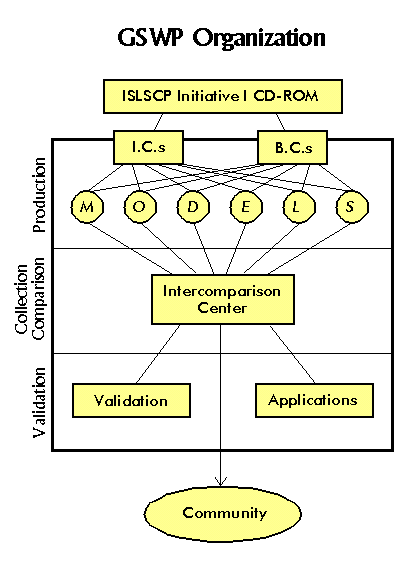
The Production Group is charged with producing a 2-year global data set of soil moisture, temperature, runoff, and surface fluxes by integrating one-way uncoupled land surface process models using externally specified surface forcings and standardized soil and vegetation distributions (namely, the ISLSCP Initiative I CD-ROM data of Meeson et al. 1995). Approximately one dozen participating LSP groups have taken the common ISLSCP forcing data to generate global data sets (see Table 1).
The period of the data is 1987-1988, corresponding to the two years of data on the ISLSCP Initiative I CD-ROM. Each model uses identical 1×1 distributions of land points, vegetation distributions, soil types, and remotely sensed biophysical data (e.g. green leaf fraction and leaf area indices), and identical radiation and meteorological forcing data. The biophysical data are supplied on a monthly interval, and the radiation and meteorological data are at 6-hourly intervals. For a complete description of the sources of these data, see Sellers et al. (1996).
Longwave radiation data are linearly interpolated to hourly or finer time steps by each modeling group. A standard code for disaggregating the shortwave radiation based on local sunrise and sunset times was provided by J. Morrill of the University of Arizona. Near-surface meteorology data was also interpolated linearly to smaller time intervals. Both large-scale and convective precipitation were provided on the ISLSCP Initiative I CD-ROM by scaling the NCEP reanalysis precipitation fields by gridded observed Global Precipitation Climatology Project (GPCP; WCRP 1990) data to preserve the observed monthly means. Most LSPs treat convective precipitation differently than large-scale, statistically distributing the precipitation so that most falls intensely over a fraction of the grid area.
Each member of the production group produced time-mean and instantaneous fields three times per month. In addition, monthly mean diurnal cycles of certain quantities are produced at a small set of grid points which correspond to locations of past and current field campaigns. These data are produced in a standard format and sent to the Inter-Comparison Center.
In addition to conducting a standard integration
to produce a data set for comparison, each LSP is used to perform specific
sensitivity studies. The sensitivity experiments are intended to evaluate
the impact of uncertainties in model parameters and forcing fields on simulation
of the surface water and energy balances. Rather than burden each participant
with the full range of sensitivity studies, each participant is examining
one or two specific issues.
1.4.2 The Validation Group
There currently exists no data set of global measured soil moisture. If there were, the Global Soil Wetness Project would not be needed. This, in a nutshell, is the dilemma of the validation effort: it will, by necessity, always be restricted to areas where data is available and will therefore never be able to completely validate the product. Thus, the validation group had modest, limited aims: to put reasonable limits on the plausibility and validity of the soil moisture estimates by comparing these against whatever data is available.
The validation group assembles data sets and
coordinates studies to validate the global products, either directly (by
comparison to field studies or soil moisture measuring networks) or indirectly
(e.g. use of modeled runoff to drive river routing models for comparison
to streamflow data). The effort can be divided along the lines of spatial
scale and assessment of the quality of the input data. By scale, validation
is done against local in situ measurements at the point or field
scale; pixel-scale validation against properties observable via remote
sensing; validation against regional scale estimates or basin scale measurements;
and "validation" against other models, ranging from energy-balance continuity
estimates to global reanalysis products. The soil wetness data produced
are also being tested within a general circulation model (GCM) to evaluate
their quality and their impact on seasonal to interannual climate simulations.
The Winand Staring Center has volunteered to lead the validation process.
1.4.3 The Inter-Comparison Center
An Inter-Comparison Center (ICC) has been established at the Center for Climate System Research, University of Tokyo for evaluating and comparing data from the different LSPs. The ICC devised a uniform format for data submission by the members of the Production Group, and in cooperation with the Production group established sets of variables and time intervals to be submitted. The ICC collected only the control simulations from each model -- Production Group members were responsible for devising and analyzing their own sensitivity experiments. Basin quality control checks were performed, like those implemented for Project for Intercomparison of Land Surface Parameterization Schemes (PILPS; Henderson Sellers et al. 1995) to insure conservation of energy and water in the models. The ICC also checked that no egregious errors were detectable in the simulations.
Key parameters are then compared between the various models, and to observations where available. The focus of the comparisons is on the simulation of global patterns, and reproduction of seasonal cycles over major river basins where precipitation and runoff data are available.
The ICC also redistributes the data from the
control simulations to other GSWP researchers involved in validation, or
who would like to use GSWP data sets in other applications. At the conclusion
of the pilot phase, the ICC intends to place a subset of the data on a
CD-ROM for general distribution, and to make a larger selection of data
available via anonymous FTP.
GSWP is not a narrowly targeted project, but attempts to address a number of issues. As a pilot project, the goals of GSWP are not merely to produce and validate global data sets of land surface hydrologic variables, but also to assess the feasibility of the processes of production and validation. Specifically, the goals of the pilot phase of GSWP can be stated as follows:
Hydrologists also require soil wetness information to initialize streamflow and basin models. Global soil wetness data could assist large-scale hydrological studies involving water balance simulations, ground water and soil chemistry modeling. Agronomists could also make use of these data in global and regional crop models, and crop yield simulations. In addition, biogeochemists and modelers of the carbon cycle need reliable data on all phases of the surface water balance. Global soil wetness and surface flux data could assist them as well. These data may also serve as initial conditions for modeling experiments of global change.
Caveats should be observed by any potential users. Although we believe that the GSWP data represent the state-of-the-art, and certain fields may represent the best global data sets available, all users should realize that the GSWP data are model products. They are not based on direct observations, although most of the data used to drive the LSPs are derived from observed quantities. Also, most of these fields are unverified, and many are unverifiable on these large scales. There is significant spread between the results of individual participating models, and no model is demonstrably superior in its performance.
Given the limitations described earlier, we thus have modest, limited aims in the validation task of GSWP. We try to put reasonable limits on the plausibility and validity of the soil moisture estimates by comparing these against whatever data is available. Part of the exercise is to test and extend the suite of available methods of large-scale validation in the face of the obvious data limitations. Thus we are not only attempting to validate the products of LSPs, but also some of the validation procedures themselves.
The ICC is not intended to conduct a thorough dissection of the participating models, nor is it a "beauty contest". One of the lessons of PILPS is that there is no simple diagnosis of the variations in performance among a set of LSPs. Thus, the ICC is instead focused on revealing the magnitude and character of inter-model variability, and thus quantify the uncertainty that currently exists in any simulation with an LSP. In most cases, observed quantities appear to lie within the envelope of simulated values of the set of LSPs. Thus, the set is in some ways analogous to an ensemble of weather prediction integrations -- spread is an implication of uncertainty, yet convergence does not necessarily guarantee accuracy.
The model comparison task of GSWP also fills a gap in the program of PILPS (Henderson-Sellers et al. 1995). PILPS Phase 2 comparisons are validation exercises conducted at a point (2a, 2b), a small patch (2d), or on a grid over a river basin of moderate size (2c). Subsequent phases will deal with the coupling of a number of LSPs to a common global atmospheric model. GSWP fills an intermediate step -- driving the LSPs offline with an observed/analysis set of forcing data on a global scale. The GSWP design ensures a realistic global environment for testing LSP behavior in an uncoupled mode, as global atmospheric models have less than perfect skill in simulating important LSP forcing terms, such as precipitation and downward shortwave radiation at the surface. Also, the feedbacks extant in coupled land-atmosphere models are not present in an offline mode, so each LSP can be evaluated with a clearer understanding of cause and effect.
This final characteristic has actually been an added benefit to the modeling groups participating in GSWP. Once one has set up an LSP to participate (by writing a driver program to feed the forcing data and boundary conditions into the LSP, and a post-processor to produce output consistent with the established GSWP formats), one has created a valuable tool for sensitivity testing and model development. The GSWP framework can be used to test both small and large changes in an LSP, ranging from calibration of a specific parameter to implementation of major changes to model formulations. Without the feedbacks of a completely coupled system, the impacts of LSM changes can be diagnosed more easily. These tests can be conducted quickly and inexpensively, compared to similar high-resolution global tests in a coupled land-atmosphere model, which can be quite computationally expensive.