3. Production Group |
| Sensitivity Studies | GCM Applications |
Most of the production groups listed in Table 1 performed a set of sensitivity tests with their LSPs in the GSWP framework. These experiments are listed in Table 3 and are described in this section. In addition, two groups performed seasonal GCM integrations based on their results in GSWP. An overview of those results are given at the end of this section.
Table 3. LSP sensitivity experiments.
| Investigators | Model | Sensitivity Study |
| Boone and Wetzel (1999) | PLACE | Soil heterogeneity |
| Douville et al. (1999) | ISBA | Soil depth, convective precipitation, runoff |
| Dirmeyer and Zeng (1999) | SSiB (COLA) | Infiltration |
| Teruyuki and Sato (1999) | JMA-SiB | Soil depth |
| Mocko and Sud (1999) | SSiB (GSFC) | Snow |
| Pitman et al. (1999) | BASE | Leaf area index |
| Morrill et al. (1999) | BATS | Downward longwave radiation |
Once control integrations were completed and their results sent to the ICC, most of the members of the production group endeavored to perform one or more sensitivity studies to investigate a particular parameterization or element of the climate system which either was poorly simulated by their LSP, or which carried a scientific or practical matter worthy of examination. The range of studies is not comprehensive -- indeed, many of the original questions the pilot project originally planned to addressed were not dealt with. Nonetheless, the studies conducted were fruitful and have shed light on some interesting issues.
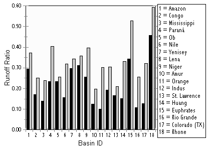
Boone and Wetzel (1999) test the validity of using aggregated soil parameters at 1×1 resolution by comparing to a simple explicit treatment of heterogeneous soils. This is motivated by the fact that hydraulic conductivity has been observed to vary by two orders of magnitude over very small distances. The non-linear dependence of soil moisture and heat transport on hydraulic conductivity and matric potential places in doubt the veracity of any simple aggregation of these parameters. To test the impacts, they define in PLACE three separate sub-surface water columns in the soil, based on expectations of the sub-grid scale distribution of sand and clay in each grid box.
 One
column uses the Clapp and Hornberger (1978) soil hydraulic properties as
defined for the soil texture classes on the ISLSCP Initiative I CD-ROM.
The other two have properties at ±1 standard deviation, estimated
for each soil texture class as in Cosby et al. (1984). The columns do not
interact, each has identical vegetation and specified atmospheric forcing,
and the fluxes computed from each column are averaged based on an assumed
Gaussian distribution of their areas. They find that evapotranspiration
is reduced globally an average of 17%, and runoff is increased by 48%,
with considerable spatial variability in the changes of each. The impacts
are more evident in drier soils. The changes improve the partitioning of
runoff between surface and subsurface components and the simulated runoff
ratios (runoff normalized by precipitation). On river basin scales, runoff
ratios generally increase by 0-30% (Figure 5).
One
column uses the Clapp and Hornberger (1978) soil hydraulic properties as
defined for the soil texture classes on the ISLSCP Initiative I CD-ROM.
The other two have properties at ±1 standard deviation, estimated
for each soil texture class as in Cosby et al. (1984). The columns do not
interact, each has identical vegetation and specified atmospheric forcing,
and the fluxes computed from each column are averaged based on an assumed
Gaussian distribution of their areas. They find that evapotranspiration
is reduced globally an average of 17%, and runoff is increased by 48%,
with considerable spatial variability in the changes of each. The impacts
are more evident in drier soils. The changes improve the partitioning of
runoff between surface and subsurface components and the simulated runoff
ratios (runoff normalized by precipitation). On river basin scales, runoff
ratios generally increase by 0-30% (Figure 5).
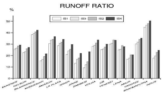
Several specific changes were tested in the sensitivity studies of Douville et al. (1999) with the ISBA scheme. Douville (1998) found that basin-scale runoff appeared to be under-predicted in the original GSWP control simulation. Douville et al. (1999) identified three likely causes of the errors. One was the treatment of the convective portion of the specified precipitation. The GSWP guidelines designate that the 6-hourly meteorological forcing data be interpolated linearly to hourly time steps in integrations of the LSPs. This leads to a rather gentle rate of convective precipitation. They addressed that shortcoming by concentrating the convective precipitation during the first two hours of each six hour period during which it occurs. In progressive experiments they added the rainfall runoff scheme of Dümenil and Todini (1992), and with decreased soil depth where the rooting depth, rather than the total soil depth, is used to specify the total depth of the ISBA soil column. Each of these changes added to the runoff over major river basins (Figure 6), increasing the global ratio of runoff to precipitation from 27% in the control integration to 33% when all three changes were implemented.
Dirmeyer and Zeng (1999) examine how a number of different elements of the GSWP implementation of COLA-SSiB affect the infiltration of precipitation and snowmelt. They focus on six large regions which exhibit significant seasonal-scale variations in precipitation between 1987 and 1988. These areas are over Alaska, South Africa, and Australia during March-May; and over South America, South Asia, and the Sahel during June-August. With the exception of the South American region, these areas had more rainfall during 1988 than in the corresponding season of 1987. They examine the impact of the treatment of convective precipitation, specification of a vertical profile of soil porosity, and the thickness of the surface soil layer on the surface water budget. When convective precipitation is given temporal variability in a slightly different manner than Douville et al. (1999), with 50% during the peak hour, and 80% during the peak three hours of a six hour interval; or alternatively the parameterization of spatial variability of convective rainfall in SSIB is turned off, runoff, direct soil evaporation and the storage of moisture in the soil matrix are affected. There is very little change in transpiration by vegetation, despite the changes in soil moisture. As in Douville et al. (1999), as the representation of variability increases, runoff increases at the expense of soil moisture and evaporation. Specifying a porosity profile where the shallow soil layers are aerated and deep layers are compacted had a relatively small impact on the water balance. Decreasing the surface soil layer thickness from 5 cm to 2 cm caused notable decreases in direct surface evaporation, and increased runoff. Transpiration was generally affected only where canopies were sparse, such as over shurbland.
Sato and Nishimura (1997) examined the impact of the depths of the surface and root zone soil layers in JMA-SiB. Sensitivity experiments include changing the thickness of the surface layer from 5 cm to 2 or 10 cm, and perturbing the root layer by either doubling or halving its depth. When the partitioning or precipitation between runoff and evapotranspiration over major river basins is compared, they find that changes to the surface layer have the greatest impact at high latitudes. Impacts for changes in the root layer depths were usually larger, with moist low-latitude basins also showing large effects. In general, evapotranspiration is increased and runoff decreased when soil depth is increased.
Pitman et al. (1999) conduct a thorough examination of the role of LAI in the simulation of the surface water budget in the BASE model. The control integrations for GSWP are conducted with spatially and monthly varying values of LAI, greenness (or albedo) and vegetation cover fraction specified identically for all models. In sensitivity studies, LAI is also specified only as a function of month and vegetation type (with the value for each vegetation type calculated as the mean for all points of that type), plus and minus one standard deviation from that mean value, and as a single global mean value. To investigate the impact of data resolution, additional cases with LAI values aggregated to 2×2 and 4×4 are performed. Integrations with LAI values shifted forward and back by one month are also conducted. The model showed a sensitivity of about 1 mm d-1 , and changes in soil wetness of 0.05 to 0.1 (as much as 1/3 of the range of soil moisture) for variations in LAI of ±1 standard deviation. This high sensitivity suggests that LAI needs to be carefully prescribed in LSPs.
Sensitivity experiments with BATS were used
to investigate the impact of a suspected phasing error in the 6-hourly
longwave radiation on the ISLSCP Initiative I CD-ROM (Morrill et al. 1999).
They show evidence that suggests the longwave radiation forcing should
be shifted forward in time by six hours. Making this correction causes
the upward longwave radiation from the surface to increase slightly during
the day, but decrease at night for a net decrease. Sensible and latent
heat flux each experience a net increase, driven predominantly by daytime
changes, but the changes in latent heat and other water balance terms are
relatively small, except in well watered regions of the globe. Simulations
where daily mean values of downward longwave radiation are specified have
a similar impact on the diurnal cycle and monthly means.
The ultimate test of the validity of the GSWP-product is to use it for the purposes for which is was developed, i.e. model initialization. Two of the production group teams have used their GSWP products as initial or boundary conditions in coupled land-atmosphere climate models, and those preliminary results are given here.
Mocko et al. (1999) also conducted GCM sensitivity
experiments to evaluate the impact of their improved snow parameterization
in a coupled framework. Using the GEOS GCM (Takacs et al. 1994) with GSFC-SSiB,
they found that the simulation of precipitation at middle and high latitudes
was improved, probably due to the increase in soil moisture characteristic
of the improved snow scheme. The GCM performs well in simulating the 1987
drought over India and the interannual variation of rainfall over the Sahel.
However, it does not capture the 1988 drought over the United States in
either integration, despite the fact that land surface fluxes are comparable
between the offline and GCM implementations of SSiB.